Features:
» Global Mapper supports viewing of dozens of the most common data formats
» Provides direct access to DigitalGlobe high resolution color imagery
» Provides direct access to the complete TerraServer-USA satellite imagery and topographic map archive
» Provides easy, direct access to WMS data sources
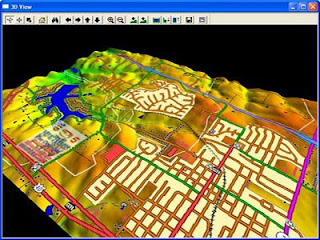
» Supports true 3D viewing of loaded elevation data including draping of any loaded imagery and vector data over the 3D surface
» Crop, reproject, and merge any combination of raster data and elevation data, including DRGs
» Digitize new vector (area, line, and point) features by drawing them with the mouse
» Track a compatible GPS device connected to your computer's serial port or USB port in real-time over any loaded data
» Support accurate conversions between a large list of projection systems and datums
» Export both vector, raster, and elevation data to a variety of formats
» graphically rectify (georeference) any JPG, TIFF, or PNG image and save the results to a new image
» Create contours for any combination of elevation data
» Automatic triangulation and gridding of 3D point data sets
» Support for combining/comparing terrain surfaces
» NASA World Wind Support
» Google Maps Support
» Virtual Earth Support
» Advanced screen capture
» Batch conversion of almost any input data data files to any compatible export type
» Auto-clip collar for DRGs/DOQQs/BSBs
» Advanced measurement capabilities
» Supports the easy creation of geological features
» Advanced drawing capabilities
» Ability to link vector feature attributes to web sites or files
» Support the latest DEM and SDTS DEM formats
» Supports opening DLG-O and DEM files directly from gzipped archives
» Supports keyboard navigation
» Search and edit load vector data by name, attribute value, or description
» Load and display JPG images with embedded EXIF positioning data
Help Us to click on Facebook Like one more....!
Download Link:Global Mapper v13.00 (x86) | 51.3 MB
Global Mapper v13.00 (x64) | 47.0 MB


No comments:
Post a Comment